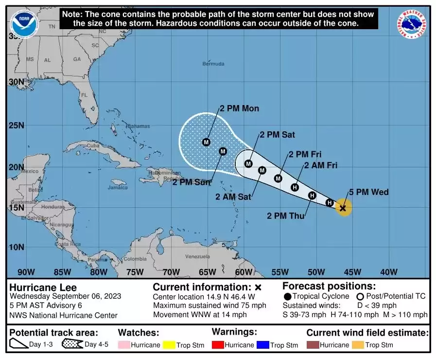
Hurricane Lee path, tracker: "extremely dangerous" storm predicted
Tropical Storm Lee has intensified into a hurricane and is expected to become "extremely dangerous" by the weekend, possibly reaching Category 4 status. Experts warn of life-threatening weather conditions and urge residents in the projected path to monitor the storm closely. The hurricane is forecast to generate hazardous waves and currents along the East Coast of the United States. It is also expected to bring tropical storm-force winds to Puerto Rico, the Dominican Republic, Haiti, and the Leeward Islands.
Tropical Storm Lee has rapidly intensified into a hurricane and is expected to become "extremely dangerous" over the weekend, potentially escalating to a Category 4 hurricane, warn experts.
According to the National Hurricane Center (NHC), Lee was upgraded to a Category 1 hurricane on Wednesday and is projected to become a "major hurricane" by early Saturday.
As of Wednesday evening, the hurricane had reached wind speeds exceeding 75 mph and was steadily gaining strength, as confirmed by Kelly Godsey, a senior service hydrologist and meteorologist with the National Weather Service (NWS) in Tallahassee, Florida, during a phone interview with Newsweek.
Godsey explained that Lee is benefiting from "extremely favorable" conditions, including warm ocean water and minimal wind shear, which are contributing to its rapid intensification.
"Storms like these can escalate rapidly," Godsey emphasized. "Lee is expected to become a major hurricane by Friday and astonishingly, a Category 4 hurricane by Saturday, as it approaches the Leeward Islands, the U.S. Virgin Islands, and eventually Puerto Rico on Sunday."
Currently, Hurricane Lee is moving northwest through the Caribbean Sea at an approximate speed of 14 mph, according to the NHC.
While it is still too early to determine if Lee will make landfall, Godsey cautioned that even if the hurricane remains offshore, it could still pose life-threatening weather conditions.
"Whenever a storm of this magnitude approaches a landmass, it generates hazardous surf and life-threatening rip currents," he explained. "So, even if Lee stays well offshore of the Leeward Islands and Puerto Rico, residents in those areas need to remain vigilant as the storm approaches and passes by."
At present, there are no coastal watches or warnings in effect, as stated by the NHC. However, Godsey emphasized that this could change, urging residents in the projected path of the storm to closely monitor its progress.
The NHC predicts that swells generated by Hurricane Lee will reach portions of the Lesser Antilles on Friday, followed by the British and U.S. Virgin Islands and Puerto Rico over the weekend. These large waves are expected to cause "life-threatening surf and rip current conditions," according to the NHC.
Godsey further warned that even if the storm does not directly impact Florida or the mainland U.S., severe weather conditions could still reach coastal communities.
"It's like dropping a rock in a pond; the ripples spread in all directions," he analogized. "As Lee continues to move northwest and approaches Florida, the swells or waves from the storm will move toward the east coast of Florida and the East Coast of the United States, generating dangerous and potentially life-threatening currents."
He cautioned that hazardous beach conditions could be expected as early as next week.
"Even if Lee remains far from the east coast of Florida, we will still experience hazardous beach conditions," Godsey stressed.
According to Godsey, Lee is expected to maintain hurricane status well into next week. If it intensifies into a Category 4 hurricane, it could bring winds surpassing 130 mph.
Puerto Rico, the Dominican Republic, Haiti, and the Leeward Islands are expected to experience tropical storm-force winds, which can reach speeds of up to 73 mph.
"This is an opportune moment for everyone to review their hurricane preparedness plan," Godsey advised. "With the peak of hurricane season approaching on September 10, it is crucial for residents along the East Coast of the United States to ensure they have a well-prepared plan in place in case a storm approaches their community."


Comments on Hurricane Lee path, tracker: "extremely dangerous" storm predicted